Thursday, December 21, 2017

NEW ZEALAND – SPECIAL TIMES WITH MILA


            “Childhood is the most beautiful of all life's seasons.”
                                                                    -Author Unknown

     Our family journey to New Zealand this past November included our 3 1/2-year-old granddaughter, Mila. We felt blessed to have her along. Ron and I found that in some ways she was easier to travel with than our own children were—probably because her parents were never more than a cell phone call away.

     Here are some special times that Mila and I had together in this child-friendly nation, south of the equator, and 6,500 miles from home:

    
     On Mila's first morning in New Zealand (Ron and I arrived two days earlier) we headed out early to find the Up Cafe for breakfast. She asked for my map so she could pretend to help me find the way because I told her I was a little lost as usual. Once we found the restaurant, she ordered hot chocolate which she drank by the spoonful. It took over an hour to finish, and she did not want anything else to eat. Perhaps we could count the two marshmallows that came with it as breakfast.

    
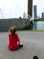
   When returning from Silo Park, located on the waterfront in Auckland, we arrived at the pedestrian lift bridge, Wynyard Crossing, just as the gate was closing. Mila quietly sat down on a nearby embankment and watched intently as the bridge lifted for a passing boat.

    
   Whenever Mila and I were out together, she immediately gave us each an assigned name for the day. Most often, she was Elsa and I was Anna—characters from her favorite Disney movie Frozen. One day, when we were at a playground in Queenstown, Mila told a little Chinese girl that her name was Elsa, and then she held out her arm and told the girl's little brother to freeze when he was misbehaving. I just hope she doesn't use fictitious names when she's trying to make new friends in her neighborhood.

    
New Zealand is a wonderful child-friendly nation. In addition to numerous playgrounds, the restaurants often have little play areas or shelves full of children's books and toys. I also noticed that the locals took time to stop and visit with Mila. The museums often had areas dedicated to children. The world famous Museum of New Zealand Te Papa Tongarewa in Wellington, with its many discovery centers for children, provided hours of creative play for Mila and a much needed break for her parents.

    
We stayed at a lot of nice places on our journey. However, if Mila were to choose her favorite, it would be, without a doubt, the Red Tussock Motel in Te Anau. This is because of the little swing set (the kind that we had in the 50s and 60s) with just two swings and a small slide that she spotted immediately. I think it was the first time in her life that she had her own private swing set that she could enjoy to her heart's content.

     We returned to Auckland at the end of our journey shortly after Thanksgiving and the beginning of the Christmas season. As Ron, Mila, and I were walking along Queens Street on our last day, Mila noticed the colorful animated window display at Smith & Caughey's. This is the oldest and most loved department store in Auckland. They decorate their windows annually for children to enjoy. This year it was based on the children's book A Pirate's Night Before Christmas. Grandpa read the script to her, while they happily walked along, looking at each of the displays, as the music played. For many Aucklanders, it's not Christmas until they've experienced these windows in all their glory. So come all ye pirates, joyful & otherwise. .” by author, Philip Yates.

     Mila still remembers the window display in Auckland because she mentioned it last night while we were watching the San Diego boat parade. It also had a santa pirate theme.

    I wonder how many other events from her 30 days in New Zealand she will remember through the years. 


Thursday, December 7, 2017

MILFORD SOUND NEW ZEALAND—MY FAVORITE PLACE

MILFORD SOUND

     What was your favorite place?: a common question most of us
are asked when we return from a trip, and sometimes I don't have an obvious answer. One highlight of my trip to New Zealand in November was the Milford Sound. In fact, this two-hour cruise on the fjord out to the Tasman Sea and back was one of the most spectacular scenic boat rides of my life. I stood outside on the deck, most of the way, observing the incredible beauty of this ten-mile long, narrow inlet (fjord) surrounded by steep cliffs capped with fresh snow. Dozens of waterfalls completed the scene. The towering beauty and majesty of the famous Mitre Peak (5,522 feet) stands above them all. It is so named because of its resemblance to a bishop's mitre.

    
SEALS  IN MILFORD SOUND
The ship moved slowly up and down the inlet for the 10 miles to the sea with our commentator pointing out sights along the way. Passengers could move around and choose to sit or stand on any of the three floors of the catamaran, both inside and out. Seals, penguins, and dolphins frequent the waters here; we were fortunate to see them all. Our captain went up close to the rocks and slowed the boat so we could get a good view of the rare Fjordland crested penguins—I think the staff was just as thrilled as we were to see them as they will depart soon when the nesting season ends. They also pointed out seals sunning themselves on a rock. We then had the benefit of observing bottlenose dolphins that are among the largest in the world.

    
WATERFALLS OF MILFORD SOUND
   One of the popular events of the cruise is to give interested passengers an opportunity to stand outside on the front deck and experience what it's like to be directly under a large waterfall. I happened to be at the bow of the boat when they announced that the waterfalls were ahead of us. I decided to stay on deck to see what it was all about. After all, my new hooded jacket was suppose to be waterproof. We did get drenched, but it was fun. I stayed dry, except for my jeans. The crowd was also singing “Happy Birthday” to a woman whose friends apparently thought that getting drenched under a waterfall was the perfect birthday present.
  
     Milford Sound (pop.120) is known to be the wettest inhabited place in New Zealand and one of the wettest in the world. The annual rainfall is 252 inches. It is still beautiful in the rain as they say, however, I don't think it could match the perfectly sunny and warm day that we experienced. Like everything else in life, a little bit of luck helps. (The week before, it snowed here, and the road to Milford Sound was closed for a day.).
JOHN, ARE YOU READY FOR THE MILFORD TRACK?

     For most visitors the two-hour drive on winding mountainous roads with single lane tunnels and bridges is a requirement to see the Milford Sound. The road was completed in 1953, and the 75-mile drive to Milford Sound from Te Anau has earned World Heritage Highway status for its beauty. Milford Trek, acclaimed as one of the great walks of the world, ends at Sandfly Point in Milford Sound. The challenging 55 km (34 miles) hike goes in one direction only and takes fours days to complete. Reservations must be made in advance.

     Milford Sound is located in the Fjordland National Park on the west coast of the south island of New Zealand. With over a half million visitors per year, it is the most popular of the 15 fjords located in the park, also notable are Doubtful Sound and Dusky Sound. Although named otherwise, the sounds are fjords which are valleys carved by the pressure and power of glaciers during successive Ice Ages. They were later flooded by the sea as the ice melted and sea levels rose.
MILFORD SOUND

Wednesday, November 29, 2017

NEW ZEALAND TRAVELS - A SWEET ENDING


     It was our last night in Auckland, and I needed to take one last stroll down Queen Street before turning in for the night. Then, I remembered those delicious-looking Hokkaido Baked Cheese Tarts that I hadn't tried yet. This was my last chance to try one of the freshly baked gems. Fortunately, the little yellow bake shop on Queen Street was still open.

     Now you must know that I am not a real foodie, and writing about food on my first post after traveling around New Zealand for a month is a little unusual. However, I can not forget those tasty little creamy, puffy, cheese tarts, with the buttery crust—by far the most scrumptious dessert I've ever had. 

     The company that produces these little gems is based in Malaysia. However, the inspiration for them came from the Hokkaido dairy of Japan. The original Hokkaido Baked Cheese Tart stores first launched in Malaysia in mid-2016 and have become a huge hit throughout Asia. The Auckland location (350 Queen Street) recently opened in August.

      The Malaysian firm, that produces the Hokkaido Baked Cheese Tarts, combines three unique cheeses to produce the savory and tart taste that makes them so famous.

     Remember that no matter how long you have been traveling, and how tired you are, there might be something new, interesting or tasty just around the corner.


Saturday, November 18, 2017

SPANISH LANDING PARK - SAN DIEGO WATERFRONT PARKS


     Sixty-thousand passengers per day are expected to pass through the San Diego International Airport over the Thanksgiving holiday period. Hopefully, some of the harried travelers will take time to notice and enjoy this very special park across the way.

     Spanish Landing Park, 3900 North Harbor Drive, is a mile-long, narrow 21-acre park that parallels the busy road on one side and the West Basin with the marinas of Harbor Island on the other. Located directly across from the busy San Diego International Airport (also known as Lindbergh Field), this is a popular stopping-off point when visiting the airport. It offers a good vantage point for watching the booming jets land and take off. San Diego is one of the rare cities to have the benefit of a scenic park right at the doorstep of its major international airport.

     At the eastern end of Spanish Landing is the Cancer Survivor Park with eight impressive life-size bronze statues by Marlo Bartels, easily noticeable from N. Harbor Drive. They were donated by the Richard & Annette Bloch Foundation, as a tribute to the living and a reminder that cancer doesn't mean death. A nearby path leads to a large white gazebo with a vibrant-blue mosaic dome and six brightly-colored benches. There are plaques throughout with encouraging writings on them like: “Don't equate death and cancer,” and “Make up your mind that when your cancer is gone, you are through with it.”

    
A walking path and separate bikeway follow along the entire water side of the park that offer a pleasant view of the Harbor Island marinas with hundreds of yachts, fishing vessels, and sailboats. An occasional pleasure boat or helicopter passes by as I walk along the waterside path. There are benches and many eucalyptus trees for shade. At the west end of the park is a children's playgrounds, small beach and restrooms. An occasional fisherman can be found along the rocky wall facing the quay. There's plenty of metered parking available ($1 per hour).

     Located in the middle of the grounds is a historical landmark that commemorates the 1769 meeting of the Gaspar De Portolรก and Father Junรญpero Serra expeditions that lead to the Spanish occupation of Alta California. Father Serra, founder of nine California missions was canonized by Pope Francis on September 23, 2015.

     One of my favorite bike rides in San Diego is the route which starts at the Broadway Pier and extends north along the Bay and winds through Spanish Landing Park and then on to Shelter Island in Point Loma. The one-mile ride through Spanish Landing Park is always interesting. I usually go to the very end where the pavement turns to gravel and walk my bike around and under the N. Harbor Drive bridge. From here, there is a path to the clearly visible Halsey Road pedestrian bridge, which is a nice alternative to biking or walking on Harbor Drive.

     After crossing the bridge, there is the historical landmark ship, USS Recruit, which was used by the US Navy for training up to 50,000 new recruits per year from 1949 until it was closed in 1997. The landlocked “dummy” training ship was affectionately called, the USS Neversail. From here, I make a quick stop at the nearby Starbuck's (2556 Laning Road) before heading on to Shelter Island in Point Loma.
                               HAPPY THANKSGIVING! 
                     THANKS FOR READING MY BLOG!
                 

Tuesday, October 31, 2017

NEW ZEALAND-THE WORLD'S MOST PEACEFUL NATION (Ranked #2)


*MILFORD SOUND

       New Zealand . . . a place where we've never been. It's a small, isolated country, similar in size to Great Britain or Japan, but with a population of only 4.5 million compared to Great Britain (67 million) and Japan (127 million). It's consists of two major islands, the North and the South. Its known for it's rugged mountains, spectacular glaciers, picturesque fiords, rolling hillsides, miles of rugged coastline, and peaceful sandy beaches. About a fifth of the North Island and two-thirds of the South Island are mountainous. The “Kiwis” are known for their friendliness and laid-back life style.
*MOUNT ASPIRING
     Nine months ago, we heard about a promotional airfare that Air Tahiti Nui was offering from Los Angeles to Auckland, and decided to take advantage of it. Our children and granddaughter will be joining us—making it all the more exciting. New Zealand is one of those places we've always wanted to visit and this seemed like a good opportunity. I booked it for 30 days, the maximum number of days that the fare allowed, and chose the month of November which is spring in New Zealand.
     Our itinerary is mainly around the South Island because it is has the most spectacular scenery. One of the difficult things about planning this trip was deciding what to do and what not to do. Everything looks so fascinating. We also had to make sure that we allowed enough time to savor the places we did visit. I scanned travel brochures to see what the experts included in their tours. I also talked with travel agents, researched travel books and websites, and found a good touring map. Next, I put together a tentative itinerary and requested feedback from everyone. This was followed by another itinerary to review.
     Another thing I did right away was to book lodging while there was still availability and reasonable rates. I used booking.com to reserve two-bedroom apartments—all of which were cancelable. I did need to make some changes. However, booking early provided far better choices and the comfort level that I needed.
     A capsule version of our itinerary looks like this:
                                 Auckland - 3- 7 nights (different arrival dates)
                                 Queenstown - 4 nights
                                 Te Anau - 4 nights
                                 Twizel - 1 night
                                 Christchurch - 2 nights
                                 Greymouth - 1 night
                                 Nelson - 3 nights
                                 Wellington - 4 nights
                                 Auckland - 2 nights

     Another challenge was how best to navigate New Zealand, and that was probably the most difficult of all. Ron and I travel in Europe by train and bus—it works great for us and we wouldn't do it any other way. Trains are scarce in New Zealand and buses are the alternative. Most tourists prefer to rent a car, van, or camper. Our son and son-in-law had a preference for driving. We will be trying a little bit of everything: a flight to Queenstown from Auckland; a large van for one week; a car for four days; two scenic trains from Christchurch to Greymouth, and Wellington to Auckland; ferry boat rides; and a lot of walking.
     
*MacKensie Basin

*Photos courtesy of Tourism New Zealand


Wednesday, October 4, 2017

SEAPORT VILLAGE - FROM VINTAGE TO WORLD-CLASS


     Seaport Village opened in 1980 with quaint wooden buildings in a setting that resembles a small fishing town. With its more than 70 shops, galleries, and eateries, it became one of the most popular tourist destinations in San Diego. The one-and two-story buildings are surrounded by towering fig trees, meandering walkways, plazas with colorful mosaic tiles and sitting areas. This is anchored by an 1895-vintage carousel that replaced the original carousel in 2004. The plaza is designed so that concerts and entertainment can be held there. Many of the restaurants offer spectacular views of San Diego Bay and the Coronado Bridge.

     The village is built on the original site of the San Diego—Coronado car ferry landing that was demolished when the Coronado Bridge opened in 1969. In the late 70s, there were only two developers bidding on the Seaport Village project that was to cover 17 acres. For the most part Seaport Village still resembles the original plan with the same buildings and even some of the original businesses. The Village Hat Shop, Harbor House, Greek Islands Cafe, and Pier Cafe are still going strong.
    
     I recall coming to Seaport Village for the first time in 1987. Our children enjoyed the carousel and the small pond with ducks. It was the beginning of December and there was a large decorated Christmas tree. Carolers walked around making the crisp December day even more special. It was always a favorite place to visit whenever we were in San Diego.


Seaport Village is part of the 70 acres that the Port commissioners consider the most valuable land on the waterfront—it is about to be transformed into a world-class destination. Protea Waterfront Development has already been chosen from a competitive field of six developers. Their $1.2 billion proposal encompasses 70 acres of land and water between the USS Midway Museum and the Manchester Grand Hyatt. Envisioned in the plans are three hotels, retail shops and restaurants, office space, a 480-foot observation tower, a sea aquarium, charter school, and much more.

    The changes are significant, and it will be interesting to see what the future brings. However, if it was totally left up to this vintage lady, I would leave it just the way it is.

      If Seaport San Diego's master plan is approved by the California Coastal Commission in 2018, construction will begin in 2019, and the redevelopment will be completed in 2021.

                                               * * *
--September 30, 2017
    
   Just recently I decided to walk around Seaport Village. I was thinking about the future and all of the changes in the air including the destruction of these quaint little wooden buildings that currently house the shops and restaurants. Suddenly I heard sirens and noticed black billowing smoke floating across the bay. Someone said that a fishing vessel was on fire, so I headed over to get a first hand view of a burning 120-foot fishing and research vessel.
     I had walked by the fishing boat about 10 minutes before, and now it was the sight of a major fire. The Norton Sound, built in 1944, had been docked at the Tuna Harbor Pier (598 W. Harbor Drive) for the past few months. Investigation is still underway. Fortunately, the ship did not appear to be occupied at the time of the fire. There were at least 20 fire and rescue trucks in the area and about a 100 firefighters and service personnel. After careful inspection, the decision was made to let it burn and spray the exterior with water to cool the hull. It was still burning 24 hours later.
NORTON SOUND FISHING VESSEL FIRE


Wall Painting - Seaport Village


Monday, August 28, 2017

VENICE--THE CHARMING CITY OF CANALS AND BRIDGES

GRAND CANAL VENICE


     We decided to forget the crowds and visit anyway—spending our last few nights in the ancient city of Venice. It had been over thirty years since our last visit, and the beauty of its historical setting, architecture, music, and artwork was calling us back. Situated on a group of 118 small islands separated by canals and linked by 400 bridges, it is one of the top tourist destinations in the world.
VENICE CAFE

     This unique place has become a tourist mecca, causing the locals to leave the historic center and move to the suburbs at a rate of 5% a year. The local population in the old city has declined from 175,000 in 1951 to 55,000 in 2016. The center is now pretty much left to the estimated 60,000 daily visitors and those in the business of tourism like restauranteurs, hoteliers, shop keepers, and trinket sellers. The local community and soul of the old city is diminishing. However, as long as this lovely place keeps floating, and the world population keeps growing, the tourists will come.
Venice is one of the most romantic places in the world, but it's even better when there is no one around.” --Woody Allen
RIALTO BRIDGE

     The first morning, I rose early and headed out to explore the old city center before the crowds showed up. I carefully followed the signs because I knew that I could easily get lost in the most maze-like city I've ever visited. After navigating the many passage-ways, alleys, and winding streets, I arrived at the Rialto Bridge, home to the original merchants of Venice. Built of stone, it was designed by Antonio da Ponte and completed in 1591. On either side of the center portico there are covered ramps with rows of shops. This early morning I was the only one around. I strolled slowly over the bridge and back again, enjoying the view and perhaps feeling a little smug because I avoided the crowds.
SAINT MARK'S CATHEDRAL

     I continued walking another ten minutes to the Piazza San Marco (Saint Mark's Square), the principal public square of Venice that had its beginnings in the 800s. The huge ancient Piazza is surrounded by incredible architecture, monuments, and views of the Adriatic Sea. I took my time to enjoy it and to photograph it from different perspectives. The oldest known mosaic in the world (1260-70) is located above the doors to the Basilica San Marco (Saint Mark's Cathedral). It depicts the 9th century merchants smuggling relics out of Egypt for the Venice cathedral. There were just a few people wandering around at 7 am.—the museums, restaurants, and cafes were all closed.

     Venice is Europe's largest car-free city. The only way to get around is by foot or boat. There are no cars or bicycles, and at one time, they even considered banning wheeled suitcases. Push carts are used for deliveries, construction projects, and garbage collection.

     Next on the agenda was hooking up with my husband, who enjoyed a relaxing morning in our apartment. We felt fortunate to have a spacious first-floor apartment for three nights in the old city (125 euro) booked on Airbnb, where it was referred to as "sweet home with garden."
.
    
VAPORETTO/ WATER BUS ON GRAND CANAL
We found a nearby cafe for an omelet and cappuccino (8 euros) and then headed to the bus terminal to purchase a two-day travelcard (30 euros) for unlimited rides on the vaporetto, also known as the water bus. We jumped on the first vaporetto to come along and spent the rest of the morning enjoying the palace-lined Grand Canal at our leisure.
BURANO
     Another benefit of the pass is that it allows for rides on the sea to visit the outlying islands. I loved our excursion to Burano which is considered one of the most colorful places in Europe. The multicolored homes are situated along a peaceful channel that is lined with fishing boats. We walked around mesmerized by the beauty of the place and fascinated by the two-three story attached houses with shutters on the windows and curtains hanging over the doors. In the background looms the leaning bell tower of San Martino—the only church on the island. It is also home to the original Burano lace. Visitors can enter the shops, and observe the friendly, elderly ladies doing their embroidering.
     We flew back to the US from the Venice Marco Polo airport which is an easy thirty-minute bus ride from the city. We left behind a charming city surrounded by water that has been sinking for centuries. The low-lying salt marsh that it is built on is dissolving. The sea levels are rising. High tides are at an extreme level. There is heavy boat traffic speeding on the canals and the cruise ships keep coming. Despite the problems, some progress is being made. The MOSE Project, to keep high waters away from the city, is near completion. Pollution and sewage projects are underway. A ban was recently passed to eliminate cruise ships from the lagoon.
     Next time I return to Venice, I'll probably need a ticket and advance reservations to enter. Italy has already imposed visitor limitations on Cinque Terre with a tourist ticket system. I just hope that this spectacular city, with its incredible history, will be around for future generations to enjoy.


DOGES' PALACE SAINT MARK'S SQUARE


SAINT MARK'S SQUARE 
PALACE ON THE GRAND CANAL


 DOGES' PALACE AND THE ADRIATIC SEA


Tuesday, August 8, 2017

CABRILLO NATIONAL MONUMENT - SAN DIEGO

OLD POINT LOMA LIGHTHOUSE

     One of the most popular tourist attractions in San Diego is Cabrillo NationalMonument, located about 13 miles from downtown at the tip of Point Loma peninsula. It offers spectacular views of the Pacific Ocean, San Diego Bay, Coronado, and the downtown skyline. On a sunny day, it's the perfect place to enjoy a walk, appreciate the beauty of the area, and get a little history lesson at the same time. It's also a short drive from the San Diego International Airport making it a great place to take visitors for a spectacular view of the city and Pacific Ocean.
BAYSIDE TRAIL

     Juan RodriguezCabrillo was the commander of three vessels that departed from Navidad, Mexico, heading north with a mission to “discover the coast of New Spain.” On September 28,1542, Cabrillo's fleet entered what is today San Diego Bay, their first landfall along the western coast of what is now the United States. Cabrillo called this inviting harbor “San Miguel” in honor of the saint whose feast was the next day. The area was officially renamed San Diego in 1602. To commemorate his life and explorations, the national monument was established by the Park Service in 1913.

     There is an impressive limestone statue of Cabrillo on a point near the visitors center. It is a replica of the original sandstone statue that was donated to the US by the Portuguese government in 1939. It suffered severe weather damage and was replaced in 1949.
     I arrived on an April day with plenty of sunshine when acres of wild yellow encelia flowers were blooming throughout the grounds. I took my time meandering around the visitor center, enjoying the lovely views before heading over to the Bayside Trail. This is one of the most beautiful hikes in San Diego, and I try to stop by to enjoy it whenever I'm nearby. It follows an old US Army roadway and winds past several military bunkers that were part of the defense system used to protect San Diego Bay during World Wars I and II.

BAYSIDE TRAIL
CABRILLO NATIONAL MONUMENT 
    It's a 1.86 mile round trip hike overlooking the Pacific Ocean, with views that stretch to Mexico and the Cuyamaca Mountains. The first half is an easy downhill walk, mostly on gravel. The return is a gentle uphill climb with a 340 foot elevation gain. The walk offers a chance to observe the sandstone cliffs and coastal sage scrub ecosystem that is becoming increasingly rare in southern California. There are a few benches and interpretive signs along the trail highlighting common plants, birds, animals, and other facts about the area.

     Perched at the highest point of the park is the picturesque Old Point LomaLighthouse that was built in 1855. Unfortunately, high fog at this level obscured the beacon light, causing its closure as an active lighthouse in 1891. It was replaced by the current lighthouse that is located at a lower elevation, in a beautiful setting, closer to the point. The old lighthouse and keepers house are now open to the public as museums and include the original occupants living quarters. The tower of the lighthouse is open to visitors three days a year.
   The tide pools are another popular attraction of this 160 acre park that should not be missed. It is an easy drive down with convenient parking. This area is considered one of the best protected and easily accessible intertidal areas in southern California. With careful exploration and low tide, you should be able to observe crabs, starfish, anemones, snails and many other treasures of the sea.

     Cabrillo is open daily from 9 am to 5 pm. There is an entrance fee of $10 per car. Restrooms are near the visitors center and the lighthouse. Food service is not available so if you plan to linger, be sure to bring some snacks along.
                                                * * *
    Note for those over age 62, the $10 lifetime national parks senior pass will be increasing to $80 on August 28, 2017. Be prepared for extra long waits at the entrance gates because many are just getting around to purchasing them.

Related Posts: "Best Place in California" - August 2, 2014
.

Wednesday, July 19, 2017

VALLE DE FASSA - THE DOLOMITES


THE DOLOMITES

"The most beautiful architecture on earth."  --Le Corbusier, Swiss Architect
    
     The Dolomites, with their impressive peaks, jagged ridges, rock pinnacles, deep gorges, and steep rock faces, lie in the eastern section of the northern Italian Alps. The highest point is Punta Penia (10,968 feet) in the Marmolada range—often referred to as the “Queen of the Dolomites.” We recently spent a few days in May in the Val di Fassa—home to this spectacular range.

    
VALLE DI FASSA
Our base was the village of Vigo di Fassa (pop. 1,256)—one of the smallest of the seven municipalities in the valley. We arrived by bus from Bolzano—a two-hour ride providing spectacular scenery and dozens of hairpin turns as we rose 4,000 feet in elevation. We were dropped off about four blocks from the Mason La Zondra, our apartment for the next few nights. Although an uphill walk, the location was convenient to the bus stop for our daily excursions.

     We chose to stay in Vigo because it was recommended by friends who especially liked the cable car up to the Ciampedie Valley. It departs from the town center. Unfortunately, we didn't get a chance to enjoy the gentle hikes on top because the cable car was closed until June 1. As a matter of fact, most of the town of Vigo was closed in May; we were lucky to even find a restaurant open. It seems that the locals like to take vacation between the busy winter and summer seasons.

    
AVISIO RIVER
It was still beautiful, and we could easily ride buses to the larger and more active villages in the valley. We also loved the walks along the Avisio River that flows through the valley. I enjoyed an early morning hike to the historic Santa Giuliana church that is perched on a hill overlooking Vigo. 

    
CANAZEI 
The ski and summer resort of Canazei (pop. 2,000) is located at one end of the 20-mile long valley, easily accessible by bus and bike. The village, with its colorfully decorated houses and old wooden barns, is surrounded by the majestic Dolomites. It is home to the largest ski area in Europe. Cable cars take you to the top and were operating on the day we were there. It was well worth the ride up because it provided one of the most spectacular and unforgettable mountain views I've ever seen.

    
GIRO D' ITALIA
We didn't realize, until arriving in Italy, that the Giro d'Italia (Tour of Italy) was passing through Val di Fassa while were were there. In Europe, this 21-day bike race is second only to the Tour de France in popularity, and it was celebrating its 100th Anniversary.

     We decided to head over to Canazei to see what takes place in a
DECORATED PINK BICYCLES
100TH ANNIVERSARY GIRO D' ITALIA
small village that is honored with the Giros' Stage 17 finish line. When we arrived, there were already four bands setting up and playing music on this sun-filled morning. Flowers and decorated pink bicycles, honoring the pink jerseys worn by the daily winners, adorned the town. Vendors with food, beverages, and t-shirts lined the streets. The “people watching” kept getting better as hundreds of people descended upon the town to see the best bikers in the world roll in. They began arriving about 4 p.m. after the completion of another challenging day of pedaling 160 miles through the peaks and valleys of the Italian Alps. They still had four days remaining before the finish line in Milan.

Related Posts: Castelrotto, Italy South Tyrol - July 2015
                        Haybaths, Dolomites, Northern Italy - July 2015
                        Merano, South Tyrol Italy - June 2017


RACERS DEPARTING CANZEI